
An area of low pressure with a probability of cyclonic development on the Yucatan Peninsula, in interaction with a low-pressure channel on the southeast of the country and with higher atmospheric instability, will cause very heavy rains at intense points, electric discharges and the possibility of falling hail in the aforementioned regions.
A low-pressure channel extended along the Sierra Madre Occidental, in interaction with upper atmospheric instability and with the entry of humidity from the Pacific Ocean associated with the Intertropical Convergence Zone (ITCZ), will produce heavy to very heavy rains accompanied by activity electricity and possible hail fall on entities of the northwest, north, west, center and south of the national territory.
The hot to very hot environment will prevail over entities in the northwest, north and northeast of Mexico.
The mentioned meteorological systems will cause the following effects:
- Very heavy rains with intense punctual rains (75 to 150 mm) : Veracruz (south), Oaxaca (northeast), Chiapas, Tabasco, Campeche, Yucatán and Quintana Roo.
- Heavy rains with very strong punctual rains (50 to 75 mm) : Sonora, Durango, Sinaloa, Nayarit, Jalisco, Michoacán and Guerrero.
- Intervals of showers with strong punctual rains (25 to 50 mm) : Chihuahua, Zacatecas, Aguascalientes, Colima, Guanajuato, State of Mexico, Mexico City, Morelos and Puebla.
- Showers intervals (5 to 25 mm) : Tamaulipas, San Luis Potosí, Querétaro and Hidalgo.
- Isolated rains (0.1 to 5 mm): Baja California Sur, Coahuila, Nuevo León and Tlaxcala.
- Possible hail fall : Sonora, Chihuahua, Durango, Zacatecas, Sinaloa, Nayarit, Jalisco, Colima, Michoacán, Guanajuato, State of Mexico, Mexico City, Morelos, Guerrero, Chiapas, Campeche, Yucatán and Quintana Roo.
- Wind with gusts of 50 to 60 km / h : Chihuahua, Coahuila, Nuevo León, Tamaulipas, Zacatecas and San Luis Potosí.
- Maximum temperatures of 40 to 45 ° C : Baja California and Sonora.
- Maximum temperatures of 35 to 40 ° C : Coahuila, Nuevo León and Tamaulipas.
- Minimum temperatures for the early hours of Sunday from 0 to 5 ° C and possible frosts : mountainous areas of Chihuahua, Durango, State of Mexico, Tlaxcala, Puebla and Hidalgo.
For more information on tropical cyclones in the Pacific Ocean and Atlantic Ocean, or low pressure areas, check the warnings of the National Weather Service through:
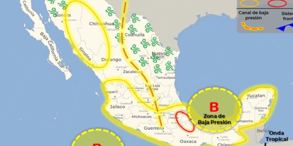
Figure 1. Meteorological systems that affect Mexico.

Figure 2. Forecast of accumulated total precipitation in 5 days.48-hour forecast from Meteorological Systems. Validity period from 08:00 a.m. on Sunday 05 to 08:00 a.m. on Monday 06 September 2021
A low pressure zone with a probability of cyclonic development will be located in the Gulf of Mexico, it will interact with a new tropical wave (No. 27) that will approach the Yucatan Peninsula and the southeast of the country, in addition to higher atmospheric instability , causing heavy to very strong rains accompanied by electric shocks and possible hail fall in the aforementioned regions, as well as in the eastern part of the national territory, with occasional intense rains in areas of Puebla, Veracruz and Oaxaca.
A low pressure channel extended over the North Mesa and the Central Mesa, in interaction with upper atmospheric instability and with the entry of humidity from the Pacific Ocean associated with associated with the Intertropical Convergence Zone (ITCZ), will produce showers and heavy rains at very strong with electrical activity and possible hailstorms on entities of the northwest, north, west, center and south of the national territory.
The hot to very hot environment will continue over entities in the northwest, north and northeast of Mexico.
The mentioned meteorological systems will cause the following effects:
- Very heavy rains with intense punctual rains (75 to 150 mm) : Puebla, Veracruz and Oaxaca.
- Heavy rains with very strong punctual rains (50 to 75 mm) : Sonora, Jalisco, Colima, Michoacán, Chiapas, Campeche, Yucatán and Quintana Roo.
- Intervals of showers with strong punctual rains (25 to 50 mm) : Chihuahua, Durango, Sinaloa, Nayarit, Zacatecas, Guanajuato, State of Mexico, Mexico City, Morelos, Guerrero, Tlaxcala and Tabasco.
- Showers intervals (5 to 25 mm) : Baja California Sur, Aguascalientes, San Luis Potosí, Querétaro and Hidalgo.
- Isolated rains (0.1 to 5 mm): Baja California, Coahuila, Nuevo León and Tamaulipas.
- Possible hail fall : Sonora, Chihuahua, Sinaloa, Durango, Zacatecas, Aguascalientes, Nayarit, Jalisco, Colima, Michoacán, Guanajuato, State of Mexico, Puebla, Veracruz, Oaxaca, Chiapas, Campeche, Yucatán and Quintana Roo.
- Wind with gusts of 50 to 60 km / h : Sonora, Chihuahua, Coahuila, Nuevo León and Tamaulipas.
- Maximum temperatures of 40 to 45 ° C : Baja California and Sonora.
- Maximum temperatures of 35 to 40 ° C : Baja California Sur, Coahuila, Nuevo León and Tamaulipas.
- Minimum temperatures for Monday morning from 0 to 5 ° C and possible frosts : mountainous areas of Chihuahua, Durango, State of Mexico, Tlaxcala, Puebla and Hidalgo.
Summary of the forecast from 72 to 96 hours (from Monday 06 to Wednesday 08 September 2021)
During the forecast period, the low pressure zone with a probability of cyclonic development will move over the waters of the Gulf of Mexico, with a trajectory towards the southeastern United States. While an area of instability with potential for cyclonic development in the Pacific Ocean will move parallel to the coasts of Colima and Jalisco, with a probable trajectory towards Baja California Sur. On the other hand, the tropical wave (No. 27) will travel the southeast, south, center and west of the national territory.
Also, a new tropical wave will approach and travel through the southeast of Mexico during Tuesday and Wednesday.
Finally, the hot to very hot environment will prevail over entities in the northwest, north and northeast of the country, as well as in the Yucatan Peninsula.
The mentioned meteorological systems will cause the following effects:
Monday 06 September 2021
- Very heavy rains with intense punctual rains (75 to 150 mm) : Chiapas, Campeche and Yucatán.
- Heavy rains with very strong punctual rains (50 to 75 mm) : Chihuahua, Durango, Sinaloa, Nayarit, Jalisco, Colima, Michoacán, Guanajuato, State of Mexico, Mexico City, Puebla, Oaxaca, Veracruz and Tabasco.
- Intervals of showers with strong punctual rains (25 to 50 mm) : Sonora, Querétaro, Hidalgo, Tlaxcala, Morelos, Guerrero and Quintana Roo.
- Showers intervals (5 to 25 mm) : Baja California Sur, Baja California, Zacatecas, Aguascalientes and San Luis Potosí.
- Isolated rains (0.1 to 5 mm): Coahuila, Nuevo León and Tamaulipas.
- Wind with gusts of 50 to 60 km / h : Chihuahua, Coahuila, Nuevo León and Tamaulipas.
- Maximum temperatures of 40 to 45 ° C : Baja California.
- Maximum temperatures of 35 to 40 ° C : Baja California Sur, Sonora, Coahuila, Nuevo León, Tamaulipas and Campeche.
- Minimum temperatures for Tuesday morning from 0 to 5 ° C and possible frosts : mountainous areas of Chihuahua, Durango, State of Mexico, Tlaxcala, Puebla and Hidalgo.
Tuesday, September 7, 2021
- Heavy rains with very strong punctual rains (50 to 75 mm) : Sonora, Chihuahua, Durango, Sinaloa, Nayarit, Jalisco, Michoacán, Puebla, Veracruz, Oaxaca and Chiapas.
- Intervals of showers with strong punctual rains (25 to 50 mm) : Colima, Zacatecas, Guanajuato, State of Mexico, Guerrero, Mexico City, Morelos, Tlaxcala, Tabasco, Campeche and Yucatán.
- Showers intervals (5 to 25 mm) : Baja California Sur, Coahuila, Nuevo León, Tamaulipas, Aguascalientes, Querétaro, Hidalgo and Quintana Roo.
- Isolated rains (0.1 to 5 mm): Baja California and San Luis Potosí.
- Wind with gusts of 50 to 60 km / h : Sonora, Chihuahua, Coahuila, Nuevo León, Tamaulipas and the coasts of Colima and Jalisco.
- Maximum temperatures of 40 to 45 ° C : Baja California and Sonora.
- Maximum temperatures of 35 to 40 ° C : Baja California Sur, Coahuila, Nuevo León, Tamaulipas, Campeche and Yucatán.
- Minimum temperatures for the early hours of Wednesday from 0 to 5 ° C and possible frosts : mountainous areas of Chihuahua, Durango, State of Mexico, Tlaxcala and Puebla.
Wednesday 08 September 2021
- Heavy rains with very strong occasional rains (50 to 75 mm) : Puebla, Veracruz, Oaxaca and Chiapas.
- Intervals of showers with strong punctual rains (25 to 50 mm) : Baja California Sur, Sonora, Chihuahua, Durango, Zacatecas, Aguascalientes, Sinaloa, Nayarit, Jalisco, Michoacán, Guerrero, Morelos, Mexico City, State of Mexico, Tabasco and Campeche.
- Showers intervals (5 to 25 mm) : Baja California, Colima, Nuevo León, Tamaulipas, San Luis Potosí, Guanajuato, Querétaro, Hidalgo, Tlaxcala, Yucatán and Quintana Roo.
- Isolated showers (0.1 to 5 mm) : Coahuila.
- Wind with gusts of 50 to 60 km / h : Sonora, Chihuahua, Coahuila, Nuevo León, Durango and the coasts of Baja California Sur.
- Maximum temperatures of 40 to 45 ° C : Baja California and Sonora.
- Maximum temperatures of 35 to 40 ° C : Baja California Sur, Chihuahua, Coahuila, Nuevo León, Tamaulipas, Campeche, Yucatán and Quintana Roo.
- Minimum temperatures for Thursday morning from 0 to 5 ° C and possible frosts : mountainous areas of Chihuahua, Durango, State of Mexico, Tlaxcala, Puebla and Hidalgo.
Watch areas for significant storm development in the next 24, 48, 72 and 96 hours

