


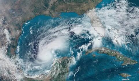
As Hurricane Isaías intensifies into a Category 3 storm, it is currently moving toward the northern Gulf of Mexico coast. While the hurricane is expected to make landfall in the United States between Florida and Alabama, its circulation will continue to bring significant rainfall and potential hazards to the Mexican state of Quintana Roo through the weekend.
Landfall and U.S. Impact
The National Hurricane Center (NHC) reports that Isaías is maintaining maximum sustained winds of 195 kilometers per hour (approx. 121 mph). The storm is currently tracking toward the coastal region between northwest Florida and Alabama, with a projected landfall between the night of Friday, October 9, and the early hours of Saturday.
Coastal communities in Mississippi also face risks from destructive winds, heavy rains, and a potentially life-threatening storm surge. Authorities in the impacted areas have reinforced evacuation measures and prevention protocols as the system is expected to begin weakening only after moving inland over U.S. territory.
Weather Outlook for Quintana Roo
Although the eye of the hurricane is moving away from the Yucatán Peninsula, its atmospheric circulation remains a concern for Quintana Roo. According to reports from Conagua, the state can expect localized heavy rainfall ranging between 50 and 75 millimeters.
While there is no threat of a direct landfall in Quintana Roo, these rains may be accompanied by lightning and could lead to significant water accumulation in low-lying areas. Residents and visitors in major tourist hubs—including Cancún, Puerto Morelos, Playa del Carmen, Cozumel, Tulum, and Isla Mujeres—are advised to monitor local weather updates, as heavy downpours may cause localized flooding and traffic disruptions.
Safety Recommendations and Precautions
Local authorities emphasize that while the primary emergency is concentrated on the U.S. coast, families in Quintana Roo should remain vigilant. Civil Protection agencies have issued the following guidelines for the upcoming weekend:
- Avoid Flooded Roads: Do not attempt to drive through streets with significant water accumulation or move through flowing currents.
- Drive with Caution: Reduce speeds during periods of intense rainfall to maintain visibility and control.
- Seek Safe Shelter: Stay away from trees, power lines, and poles during electrical storms, as these may become unstable or hazardous.
- Monitor Official Channels: Follow real-time updates from the National Meteorological Service (SMN) and State Civil Protection. Residents are urged to rely on official reports rather than unverified information circulating on social media.