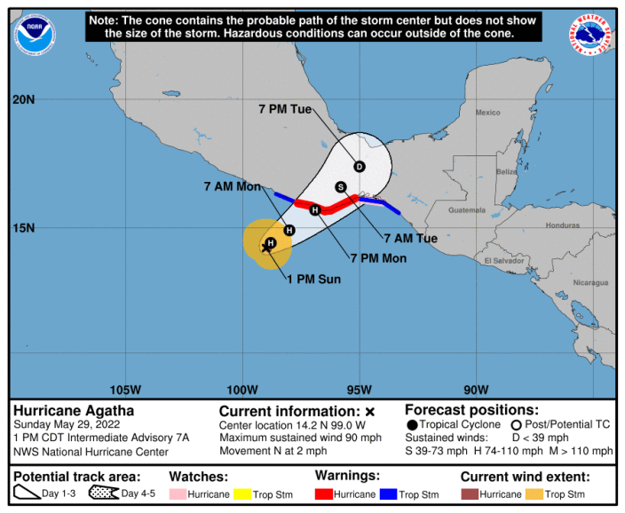
Agatha, the first named storm of the eastern Pacific season, became a hurricane Sunday morning and was “rapidly intensifying,” the National Hurricane Center said.
The storm is expected to make landfall along the southern coast of Mexico on Monday and then “quickly weaken and dissipate as it crosses Mexico,” the center said.
It’s “way too early to tell what, if anything,” Hurricane Agatha means for the U.S., meteorologist Craig Setzer wrote on Twitter on Saturday. “Right now we’re just going to be watching,” he said.
AccuWeather meteorologists noted they will be closely monitoring the “leftover energy” from Agatha as it crosses Mexico and enters the Bay of Campeche. “Here, there is a chance it could redevelop into the Atlantic basin’s first named storm,” the outlet reported.
The hurricane comes as federal forecasters expect yet another busy Atlantic hurricane season in 2022: As many as 10 hurricanes could form, meteorologists said last week. The Atlantic season begins June 1 and runs through Nov. 30; it peaks in August and September.
HURRICANE FORECAST 2022: Up to 21 named storms possible; as many as 10 hurricanes could form

Hurricane Agatha is the earliest first hurricane in the eastern North Pacific since 2015, said Phil Klotzbach, a research scientist at Colorado State University, wrote on Twitter.
As of 4 p.m. CDT Sunday, the storm was about 185 miles southwest of Puerto Angel, Mexico, moving northeast at 1 mph, according to the National Hurricane Center.
“A turn toward the northeast is expected later today, with a slow-motion toward the northeast continuing through Monday night,” the National Hurricane Center said.
Maximum sustained winds were near 110 mph and were expected to intensify until landfall Monday. Hurricane-force winds extend outward up to 15 miles from the center, and tropical-storm-force winds extend up to 115 miles, the center said.
Source: CONAGUA


